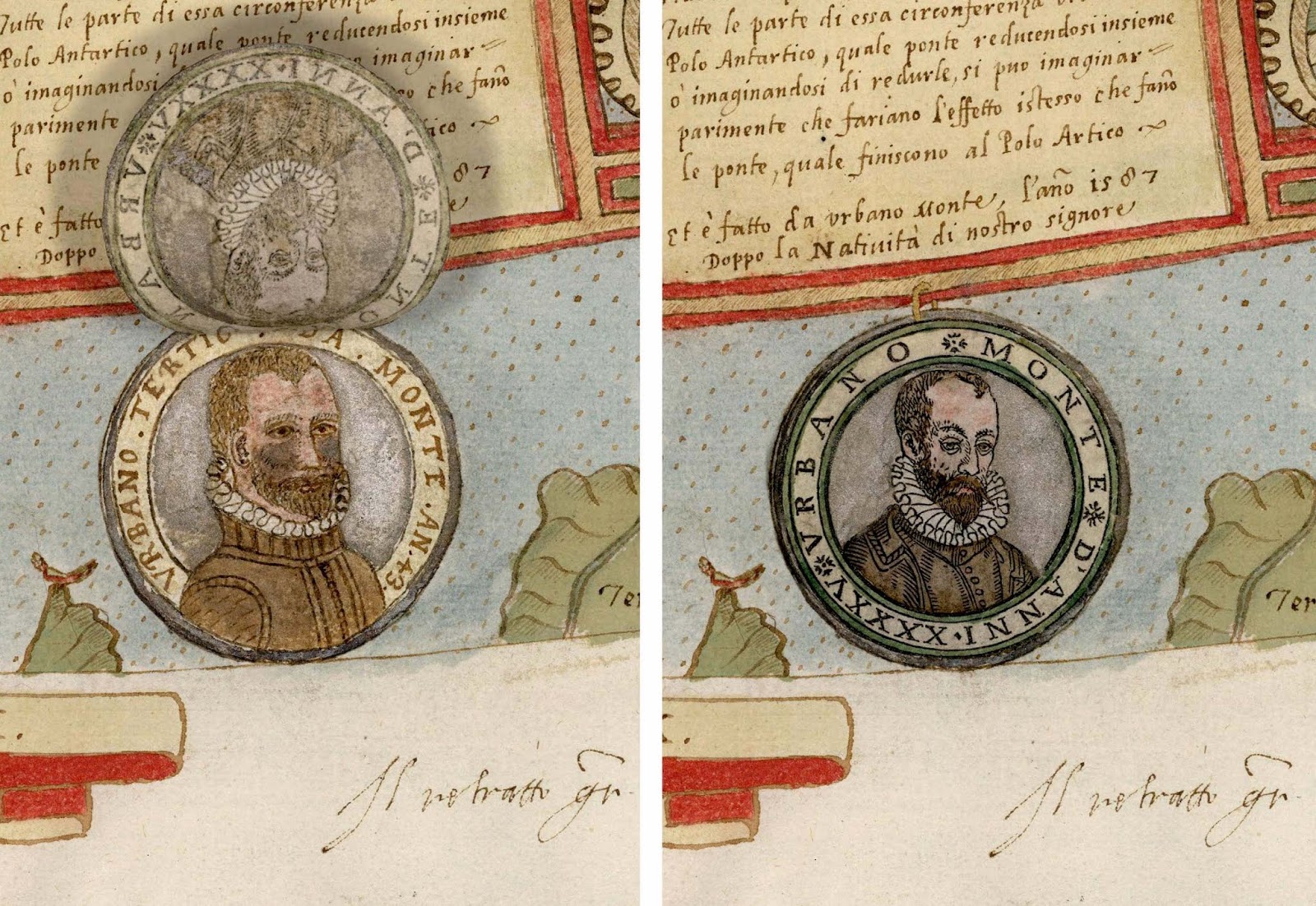
At some point in 1589, a Milanese cartographer named Urbano Monte made up his mind: his self-portrait needed updating.
Monte carefully crouched over the section of his map that bore his self-portrait from two years earlier — close-cropped sandy hair, a trim beard, modest clothes — and pasted a new self-portrait over it. The resulting double self-portrait (Monte at 43, hidden beneath a new portrait of Monte at 45) testifies to the persistence of male pattern baldness throughout human history.
It also exemplifies Monte’s astonishing attention to detail. The task he had set himself was to map every corner of the known world, not only showing cities, rivers and mountains, but giving warnings about monsters (beware the trickster spirits that lurk in Central Asian deserts) and wondrous beasts like unicorns.
If the two years that divide Monte’s self-portraits seem to have led to some lost hair and added wrinkles, we can hardly blame him. Because in that time, Urbano Monte had been hard at work creating what, for my money, is the most fascinating and wonderful map ever made.
Perhaps the most striking thing about the map is the elaborate organizational schema of the 60 sheets that comprise it. Monte intended for each of these sheets to be assembled into a vast, 9-foot-square circular world map that had a markedly different projection than the more famous style that had been adopted by Mercator some two decades earlier. As an excellent recent essay about the map explains, Monte used an innovative “polar azimuthal projection; that is, a portrayal of the globe as radiating from a central North Pole, with the degrees of latitude shown at equidistant intervals.”
 |
| A composite image of 42 sections of Monte’s map “stitched” together, as originally intended. The center of the map is the North Pole. |
And here it is in a more familiar projection:
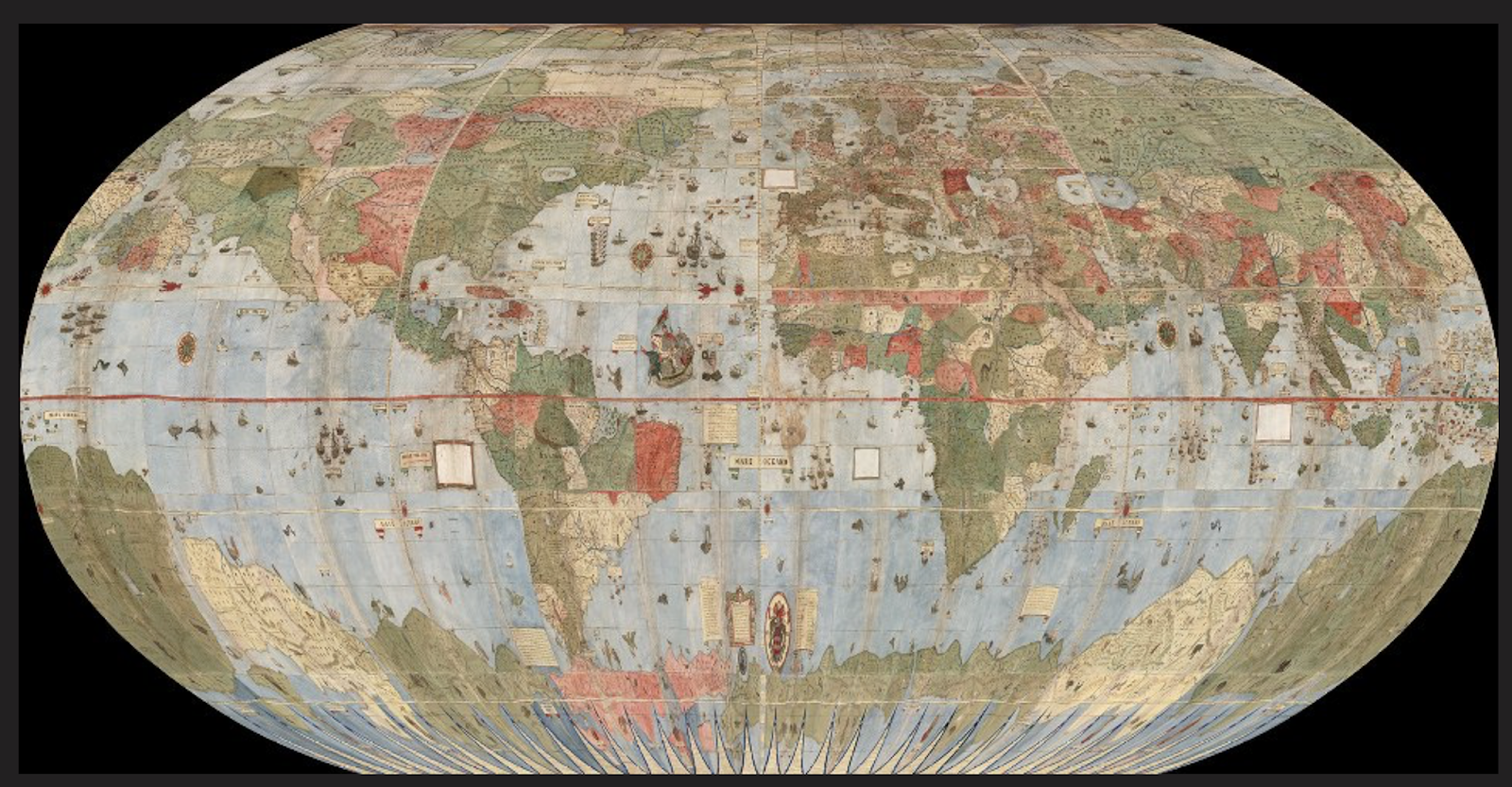
Monte’s map is quite impressive as a work of continental-scale cartography. He gets a lot of things right, relative to his sixteenth-century peers: California is not an island. Africa is fairly accurately delineated, and Europe and the Mediterranean are quite accurate. But that’s not what makes the map unique. It’s the fact that the enormous scale of Monte’s vision gave him space to crowd his map not only with a tremendous amount of local cartographic detail, but with tiny illustrated figures (of demons, monsters, unicorns, and more), mini-maps of major cities, and highly eclectic captions.
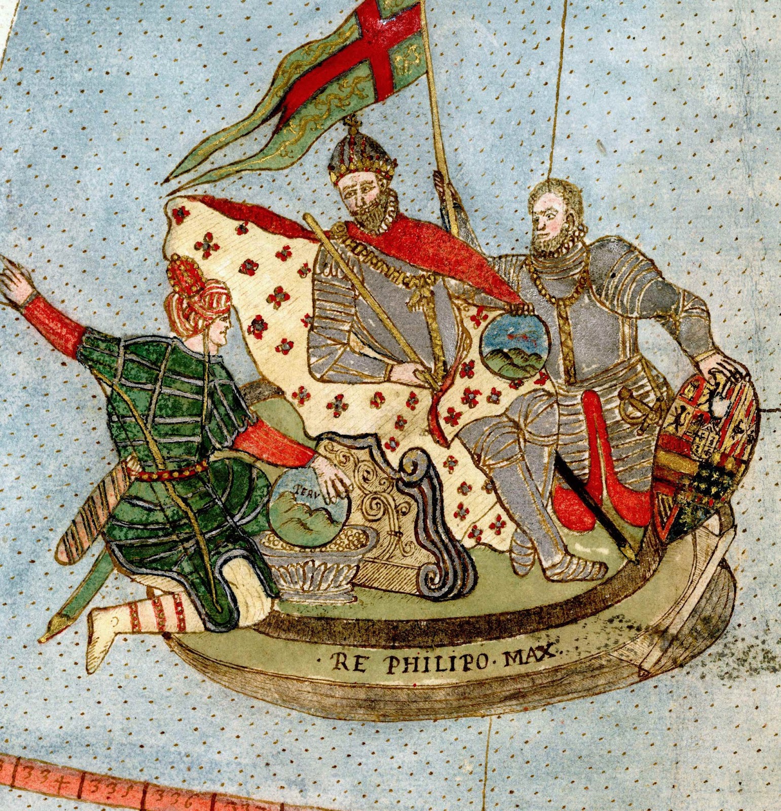
Above all, Monte’s was an ocean-oriented map. Ships of all description can be found criss-crossing his oceans. King Philip II of Spain himself — who, in his rule as Duke of Milan, was Monte’s liege lord — makes an appearance on a ship of state off the coast of Brazil. He is offered a wreath by a mermaid (“here you are, magnanimous and sovereign King,” reads a caption). King Philip holds a sphere of the world, mimicking the circular shape of the map itself. And at his side appears Atahualpa, the Inca Emperor, who offers a container of gold and a sphere labelled “Peru.” In an accompanying caption, Atahualpa says, “When subject to me and to Satan, the New World was unhappy. Now that it is your’s, it is more happy.”
 |
| An English ship off the coast of South America. Sir Francis Drake raided several Spanish colonial cities in the Americas during 1585-6, the years when Monte was beginning work on his map. Given Drake’s fame at the time, it’s not inconceivable that Monte was thinking of him. |
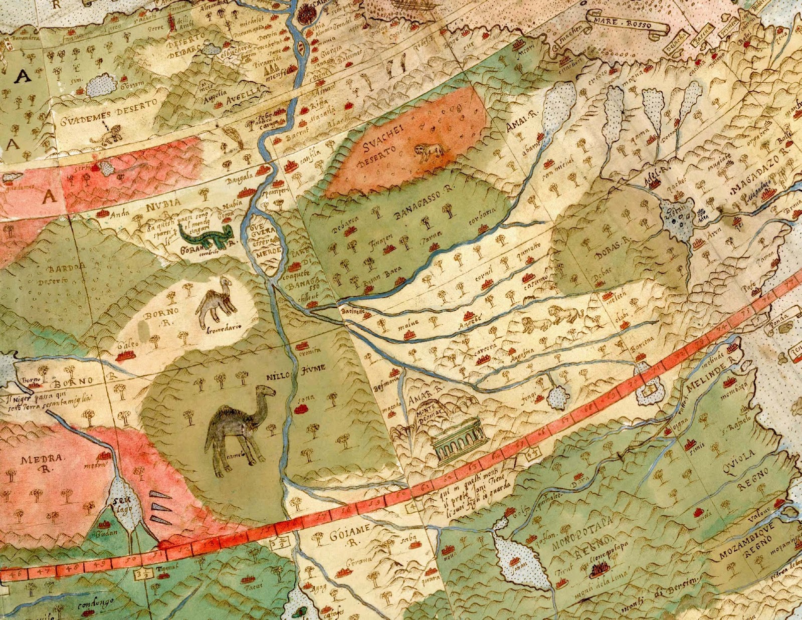
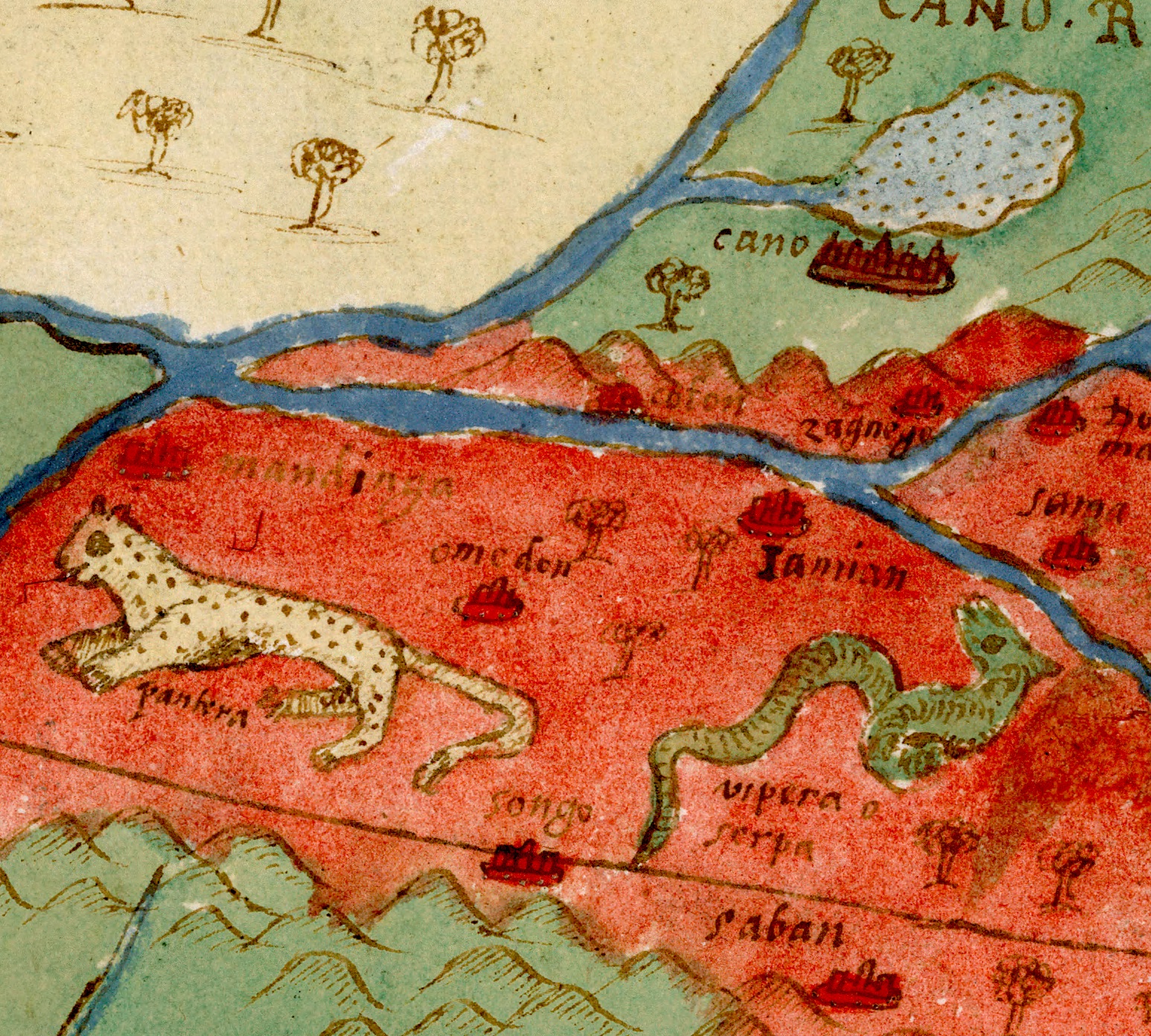
However, my favorite details in the map are not at sea, but on land. Monte seems to have been fascinated with animal life, both real and mythical. In his map of West Africa, for instance, he makes sure to include animals like the
pantera (panther) and
vipera (viper.)
As well as this somewhat dismayed looking camel:

The most wonderful details of all, in my opinion, can be found in the section of the map dealing with northern Asia. Some of the details are fairly predictable, like the many tents and wagons indicating that many of the inhabitants of the region have a nomadic way of life.
 |
| Wagons and tents of “Tartars… who have no [fixed] habitation.” |
But others are incredibly odd, like the Mongolian unicorn frolicking next to a caption that appears to be claiming that the ten Lost Tribes of Israel live nearby (“dove sono diece Tribu d’Israel”).

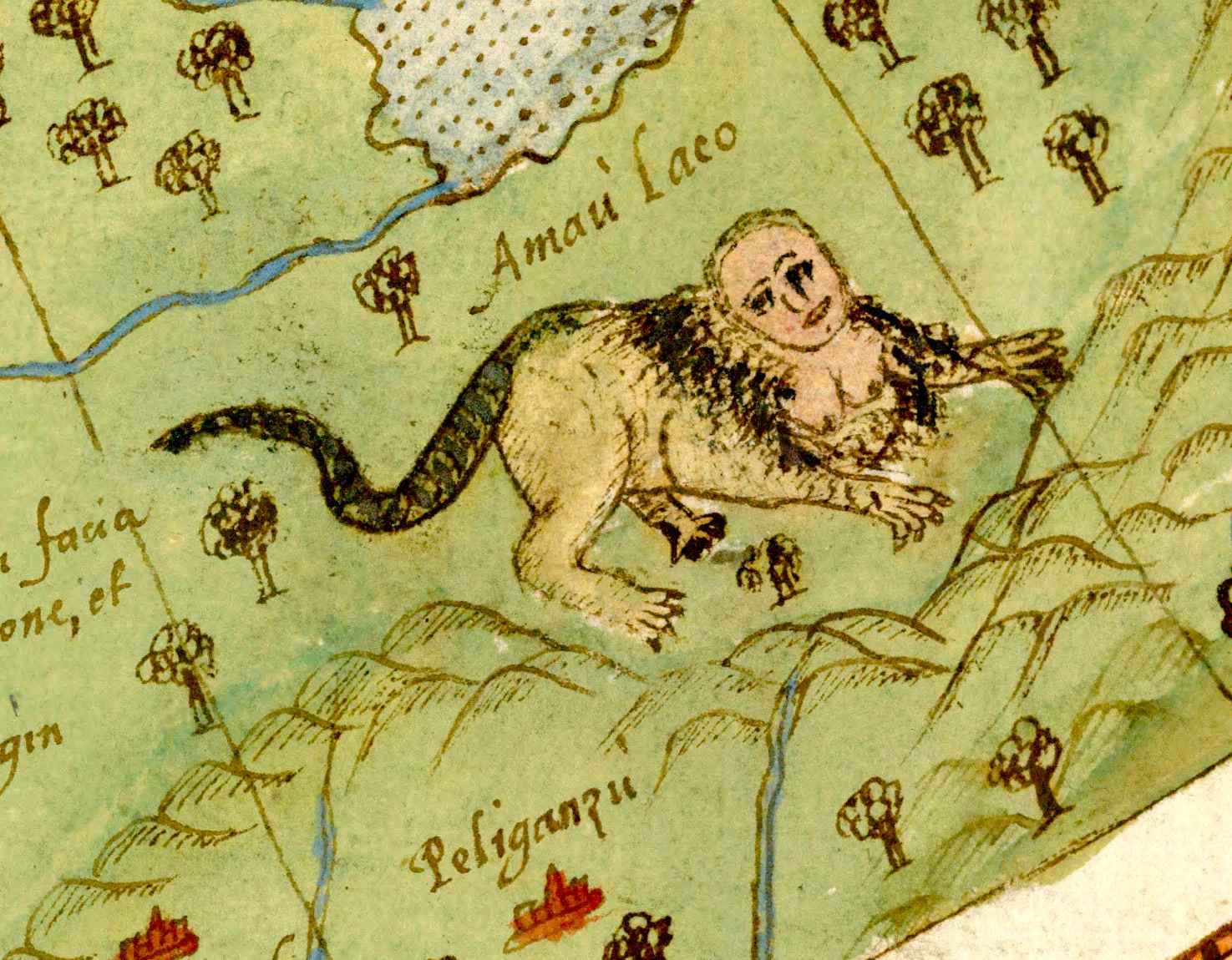
Nearby, in Manchuria, lurks the fearsome manticore, which a caption tells us “is an animal with the face of a lady, the body of a lion, and the tail of a scorpion.”
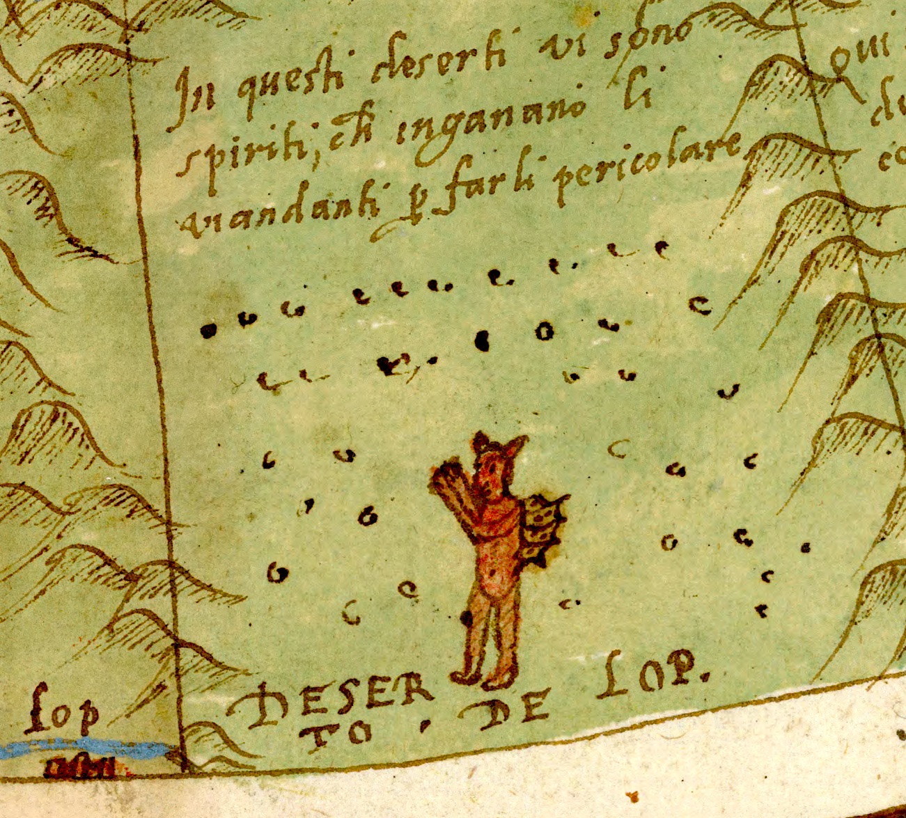
My favorite details of all, however, are the demons that lurk in the empty zones east of Persia and Turkestan. “In this desert there are spirits who deceive,” states the caption next to the city of Lop in my (admittedly poor) attempted translation from the Italian. It seems to me like Monte was digesting Persian stories about the djinn and
div who were reputed to trick desert travelers.
To round things out, here’s a final aspect of the map I found fascinating: Monte’s trading card-like portraits of what he evidently regarded as the eight leading monarchs of the earth. The list is interesting for who it leaves out. There’s no Queen Elizabeth here, and no Emperor Akbar of India. In order, the list of monarchs features:
- “The Emperor of Turkey,” Murad III.
- “The King of Spain and of the Indies,” Philip II.
- “The chief of Christians, the Pontifex Maximus,” Pope Sixtus V.
- “The great Prester John, King of Great Ethiopia,” mythical but perhaps in reference to Sarsa Dengel.
- “The King of Poland,” presumably Stephen Báthory, King of Poland and Grand Duke of Lithuania.
- “The King of Portugal,” as it happens, this was also Philip II of Spain during the 1580s! (For an explanation, begin here).
- “Matezuma who was King of Mexico and the Western Indies” – a fascinating detail.
- “[Holy] Roman Emperor,” Rudolph II. Who was Philip II’s nephew. Among other things, this map really demonstrates the degree to which the Spanish state dominated the world in the 1580s.


Personally, I think that this is the most visually compelling, detailed, and just plain interesting map I’ve ever seen. And I can’t believe I had never heard of it until today. Thanks to the
David Rumsey Map Collection for buying and making freely available one of only two known copies of the map, and thanks also to
Jorge Cañizares-Esguerra for publicizing it via Facebook, which is how I came across these scans.
If you find any of this interesting, the best thing to do is to jump right into the map itself. You can find an overview from the map’s owner and digitizer, the David Rumsey Map Collection, here.
Best of all, every section of the map is available to download in ultra high resolution here. There’s even an interactive version of the map available to explore via Google Earth.