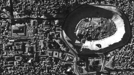
An aerial shot of Aleppo, Syria, taken by a U-2 spy plane in 1959
E. Hammer et al., Advances in Archaeological Practice 10.1017 (2019)
For millennia, people known as the Marsh Arabs lived in wetland oases fed by the Tigris and Euphrates rivers in southern Iraq. But as those marshes became a hotbed of rebellion in the early 1990s, former Iraqi President Saddam Hussein systematically drained them—driving out the people and drying up an ancient way of life. It’s hard to know exactly how many were displaced, but a new study, first reported in Secrecy News, reveals a tool archaeologists and anthropologists can use to find out: declassified Cold War–era images snapped by U.S. Lockheed U-2 spy planes. The high-resolution photos could prove a boon for reconstructing sites destroyed by development and war in recent decades.
Investigating lost historical sites and artifacts is a major challenge for archaeologists, says Emily Hammer, an anthropologist at the University of Pennsylvania and lead author on the new study. In northern Iraq, for example, an ancient canal system in the Neo-Assyrian capital of Nimrud has been paved over by roads and topped with housing projects. In recent years, the Islamic State group gutted archaeologically important Iraqi sites in Mosul and Raqqa and Syrian sites in Aleppo and Palmyra. “Older images are much better, because archaeology is in many ways a race against time,” Hammer says.
Aerial archaeologists have long used photographs from the U.S. Central Intelligence Agency–operated CORONA satellite surveillance network for just that purpose. But those images, taken from 1959 to 1972, are relatively low resolution, limiting their usefulness. In 1997, the U.S. government declassified thousands of photos taken by U-2 spy planes that flew over the Middle East, the former Soviet Union, Eastern Europe, China, South America, and Cuba during the 1950s and 1960s. Taken at 21,000 meters by sophisticated cameras strapped to the planes’ undercarriages, these photos offer a resolution that’s even better than modern consumer satellite images on Google Earth. For example, Hammer says, you can see not only villages in the Mesopotamian marshes, but also individual reed huts.
Shots from the U-2 planes allow viewers to pinpoint individual reed huts in Iraq’s Mesopotamian marshes in 1960.
E. Hammer et al., Advances in Archaeological Practice 10.1017 (2019)
Although declassified and available to the public since 1997, the U-2 photos haven’t been used by archaeologists because, frankly, it’s been a pain to access them, Hammer explains. And although the pictures themselves have been declassified, other critical information, such as exactly where and when they were taken, has not, forcing researchers to make educated guesses about those details. The archive has not been digitized, so after requesting an image from the Federal Records Center in Lenexa, Kansas—known as the “Ice Cube” because of its chilly storage temperatures—a researcher must then go in person to the National Archives in College Park, Maryland. That facility’s lightroom lacks equipment for digitizing photos, so researchers must bring their own camera setups.
To help their fellow researchers navigate the archive, Hammer and colleague Jason Ur, an anthropologist at Harvard University, created a systematized index of several thousand U-2 photos taken on 11 reconnaissance missions throughout the Middle East. It’s essentially a guide letting researchers know which locations are covered in the archive and how to request those particular rolls of film. Hammer and Ur painstakingly reconstructed the spy planes’ flight paths based on bare-bones geographic clues and their own familiarity with the region. The researchers detailed their process for other researchers to follow last week in Advances in Archaeological Practice.
So far, the team has digitized only a couple dozen photos and has not uncovered new archaeological sites. But as a proof of concept, they wrote up case studies of three previously known sites identified in the U-2 photos. In addition to the Iraqi marsh villages, they show predevelopment photos of the Nimrud canals and images of massive, prehistoric walled hunting traps called “desert kites” in eastern Jordan.
Taken in 1960, this photo shows prehistoric walled mass-kill hunting traps in the Jordanian desert.
E. Hammer et al., Advances in Archaeological Practice 10.1017 (2019)
Stephen Davis, an archaeologist at University College Dublin and chairman of the international Aerial Archaeology Research Group, says researchers will be excited to delve into this archive despite the difficulties in access. “This looks like it’s got enormous potential,” he says. “The images look much better than anything else I’ve seen from that era.”

